About
“Mapping Life in Fort McMurray” is the product of a diverse set of research interviews conducted in northern Alberta, Canada. Why Fort McMurray? Because it is the urban service area to the vast municipality (Wood Buffalo) under which sit the third largest oil reserves in the world (the Athabasca Oil/Tar Sands).
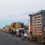
Our interviews were conducted during several crucial years in the life of the city – from 2007 to 2009 – when the bitumen boom reached an historical peak and then hit a brief downturn. By then, the population of Fort McMurray had doubled over the course of a decade to more than seventy thousand people coming from all across Canada and the globe; in the same period, the work camp population in the vast region had increased seven-fold to nearly thirty thousand people. In 2013 all of those numbers are higher still.
Yet such statistics do not capture the lived experience of these changes, let alone the radically different forms those experiences take. Our interviews asked people to describe and discuss their perspectives on the place – what we called “your Fort McMurray” – and then also to “map” it with pen and paper. The result was a rich and evocative set of visual representations coming from radically diverse vantage points, thirty-five of which appear here accompanied by short interview excerpts.
Together, these images and words foreground a variety of individual experiences of comings and goings, of place and community, of fast pace and high growth, and of relationships among work, life, and oil. We have anonymized all entries and categorized them by some of the factors that were important to shaping people’s experiences of Fort McMurray, such as how long they had been in the region, where they came from, how they identified culturally or ethnically, where they lived, and what kind of work they did. Many thanks to all of the interview participants for permission to use their maps and interviews in this research project.
In some ways these maps and interviews are a reflection of the particular time period in which they were produced, and in other ways they point to issues that remain germane. One of those issues is the impact of employment-related geographical mobility (ERGM) in the region, which has only become more complex as tens of thousands of people fly in and fly out on shift schedules, get off the bus looking for work, or experience one of the longest daily commutes in the country. This complexity is the focus of our next phase of research (2012-2019), part of a major national study of ERGM called On the Move.
This site will be open for comments from viewers until January 31, 2013. We plan to archive those thoughts – including and especially from people who have lived or worked in the region – for future visitors to the site to see. We welcome you to browse, search, explore, and comment.
All of us who had a hand in creating “Mapping Life in Fort McMurray” are affiliated with the Department of Sociology at the University of Alberta:
Social Landscapes of Fort McMurray (SSHRC Research Grant, 2007-2010): Dr. Sara Dorow and Goze Dogu.
On the Move: Employment-Related Geographical Mobility in the Canadian Context (SSHRC Partnership Grant, 2012-2019): Dr. Sara Dorow, Susan Cake, and Marcella Cassiano.
Other project-related resources:
Where is Fort McMurray: Picturing Place, Photography, Fort McMurray (youth photo project spearheaded by Dr. Andriko Lozowy)
Fort McMurray, Wood Buffalo, and the Oil/Tar Sands: Revisiting the Sociology of ‘Community’ (special issue of Canadian Journal of Sociology)
On the Move to Fort McMurray (special edition of CBC’s Ideas program, with Paul Kennedy)
Analysis of the maps was initially published in:
Dorow, Sara and Goze Dogu (2011) “The Spatial Distribution of Hope in and beyond Fort McMurray.” In T. K. Davidson, O. Park, and R. Shields (eds.) Ecologies of Affect: Placing Nostalgia, Desire, and Hope. Waterloo: Wilfred Laurier Press.
Contact

